| FAQ >Software >QTravel |
| |
| Q1 |
I want to merge tracks from different project files into one project file. Is this possible? |
| A1 |
Unfortunately different project files can't be merged together. The only way to load tracks into a project file is from GPS device directly. |
| |
| Q2 |
The height value of log data is consistently 40m-50m more to the exact value? Why? |
| A2 |
The height you see from GPS is not the height above sea level but the height above sea level plus geoid above WGS84. And because geoid above WGS84 is a relative average height of Earth, the value of it may be negative. There still exist some limits on altitude value of GPS. We suggest you this value is only for your reference. |
| |
| Q3 |
I want to import tracks into a project file such as BIN, GPX, KML, or other file formats. Can I do it? |
| A3 |
For security reason, the only way to load in tracks into a project file is through GPS device directly. We're sorry for making your inconvenience. |
| |
| Q4 |
Why my photos are not on the right location on map? |
| A4 |
It might be the daylight saving time issue.
Please adjust <Photo Time Zone> in Option and <Display Time Zone> one hour behind to match the correct positions of your photos in QTravel. |
| |
| Q5 |
After lading my log data and photos in QTravel, my photos all stick on one spot, the beginning of the track. Why? |
| A5 |
Your photo time is not within the track time range.
Please check your track time range from track properties and photo time range from 1st photo to last one. Use "Shift photo time" or change time zone to make sure all photo time is located in track time range. |
| |
| Q6 |
Can the software write GPS info to RAW file format? |
| A6 |
So far our software does not support RAW writing yet, but the following software can support RAW writing which accepts track files exported by our software for your reference.
http://code.google.com/p/gpicsync/ |
| |
| Q7 |
I typed in the key but the software reported as wrong key? |
| A7 |
Please double check the combination of the key or execute windows program " Regedit.exe " and find " HKEY_CURRENT_USER\Software\Qstarz Applications\TravelRecorder\OptionsSetting\ RegProdKey_QStarz " and directly paste your product key. |
| |
| Q8 |
I lost my software license key. How can I apply for a new one? |
| A8 |
Please email your product serial number (below the barcode on the back of the device or on the color box) to us to get a new license. But please notice that this key application is just allowed once. It's important to keep the key in safe. |
| |
| Q9 |
My tracks seem to be on wrong position where I have never been. And there are straight lines across the map. Why? |
| A9 |
When GPS is situated in low speed or not moving at all, the GPS position will drift including speed and altitude. This is because the born limitations of GPS design. Every GPS chipset in the market all have this phenomenon. |
| |
| Q10 |
Is there any way to get the software for a Mac? |
| A10 |
All of our software does not support mac OS.
The alternative way is using the following third party software.
Download log data:
http://www.houdah.com/houdahGeo/
http://sourceforge.net/projects/bt747
Geotag:http://code.google.com/p/gpicsync/ |
| |
| Q11 |
Could you provide a Linux driver? |
| A11 |
So far all of our software does not support Linux platform. However, there is a third party software which is Linux compatible with our products. Below link is for your reference:http://www.bt747.org/de/install |
| |
| Q12 |
How to change the NMEA sentence? |
| A12 |
Please download the tool QstarzGPSView from Qstarz website to adjust NMEA sentence. |
| |
| Q13 |
What is the “drift function” means? |
| A13 |
The “Drift function” is to correct the way points by deleting the low speed way points. |
| |
| Q14 |
Why the track recorder’s recorded track points is far away from the actual position? |
| A14 |
The drift point may be caused by slow speed or when you stay at a fix position for a while. |
| |
| Q15 |
I get a message that says "FAILED TO CONNECT GPS MODULE. “ Can you help? |
| A15 |
Please Check connection COM port at Windows Device Manager -> Com&LPT -> GPS USB…..or CP210X…… And Manually select connection COM port at Software>Config GPS and test again. |
| |
| Q16 |
I am having trouble to Upload AGPS data. What can I do? |
| A16 |
Please download QstarzGpsView from our website : http://www.qstarz.com/download/QstarzGpsView%20v1.2.22.rar And download AGPS from Setup -> Update AGPS |
| |
| Q17 |
How can I geotag my photos? |
| A17 |
The GPS real time is based on UTC/GMT+0 time. What you have to do is to change UTC/GMT to your local time zone by selecting Display time zone in software.
And set the correct local time with your camera. When you import the pictures from your camera, the photo time will be synchronized automatically with the local time. |
| |
| Q18 |
How can I set the time on the GPS unit? |
| A18 |
Sorry, you could not set the GPS time, all of our GPS products use the universal UTC/GMT time.
http://www.worldtimeserver.com/current_time_in_UTC.aspx
This means no matter where you use the device, the GPS time will be the same (UTC/GMT time) and the GPS device time could not be changed or modified. |
| |
| Q19 |
How can I turn off the buzzer? |
| A19 |
Please turn off the buzzer from QTravel ->Config GPS and uncheck the “Turn on buzzer” function. |
| |
| Q20 |
How can I turn off the Vibration Detector? |
| A20 |
Please disable the Vibration Detector from Software->Config GPS->uncheck “Turn on Vibration Detector” |
| |
|
| Q21 |
Why am I getting the Google Maps API error message pop up and cannot use the map function, what can I do? |
|
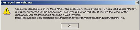 |
| A21 |
Please download and update to the latest version of the software from our website to solve this problem. |
| |
|
| Q22 |
I have recently started seeing the following warning message on the Google Map "You are using a browser that is not supported by the Google Maps JavaScript API. consider changing your browser." how to get rid of the message? |
| |
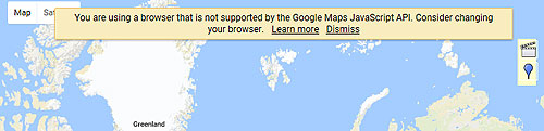 |
| A22 |
Please download the Hotfix from link below : https://www.dropbox.com/s/s8b1c6rf0t0yhnp/GMapHotfix.zip?dl=0 extract the file and double-click on GMaphotfix.reg to remove the Google map API message.
|
| |
|